

Top-Tier Training for Technically Advanced Aircraft
Practice your real-world scan with the same features you use to enhance situational awareness in the aircraft.
.gif?width=688&height=555&name=20260617-2120-22.7923073%20(2).gif)
Authentic G1000 NXi Replication
A faithful reproduction of the real Garmin flight deck, including Synthetic Vision, HSI Mapping, and end-to-end flight planning.
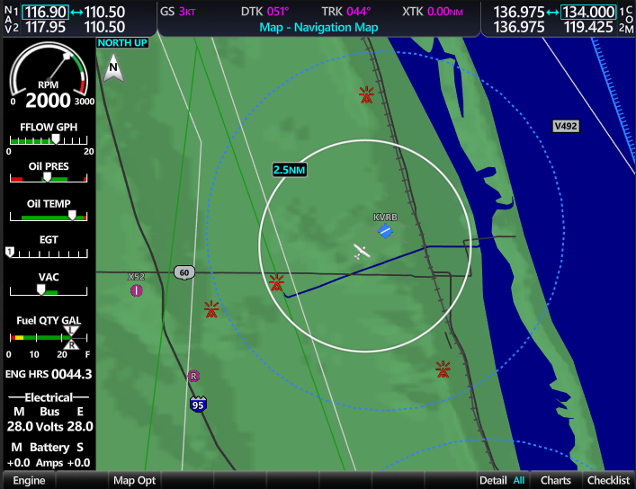
Backed by the Highest-Quality Data
Redbird NXi runs on Jeppesen NavData and geospatial data, offering worldwide coverage and access to the same aeronautical information used by airlines, corporate flight departments, and avionics manufacturers. Train on the most accurate navigation, terrain, obstacle, and cultural data, updated on the same cycles you're accustomed to in your aircraft.
.gif?width=710&height=548&name=Untitled%20-%20June%2019%2c%202026%20at%2014.06.18%20(1).gif)
Powerful Processing
Improved graphics rendering and faster zooming, panning, and redrawing speeds allow you to operate just as you would in the aircraft.
.png)
Details That Don't Distract
Familiar fonts, iconography, imagery, and animations ensure you stay immersed in the simulation.
Redbird NXi Feature Set
The Redbird NXi was built from the ground up to provide high-impact training value while keeping the interchangeability and low cost that we have always delivered.
V-Speed Bugs
Metric Overlay on Altimeter
HSI Compass & Map
Automatic CDI Scaling
OBS Mode
Temp & Wind Display
Metric Altimeter
DME & ADF
Zero Pitch Line
Airport Signs
Flight Path Marker
Horizon Heading
Runways
Obstacles
Pathways
Arrivals
Instrument Approaches
Missed Approach
FliteCharts (Garmin)
Active Flight Plan
Flight Plan Window on PFD
Flight Plan Airways
Closest Point on Flight Plan
User-Defined Holding Patterns
Flight Plan Views (Split Screen Narrow/Wide, Split Screen with Flight Plan Map)
Importing & Exporting Flight Plans
Flight Director
Vertical Modes (PIT, ALTS, ALT, VS, FLC)
Lateral Modes (ROL, HDG, GPS, VOR, LOC)
Combination Modes (GP, GS, VNAV)
AFCS Annunciations & Alerts
Overspeed Protection
Underspeed Protection
Control Wheel Steering
Abnormal GPS Conditions
Unusual Attitudes
Hot Spots
Ramps
Buildings
Control Towers
Auto Turing COM & NAV
Marker Beacon Receiver
Mode S Transponder
Aviation Symbols
Airspace Symbols
Track Vector
Selected Altitude ARC
Visual Reporting Point
Temporary Flight Restriction
VNAV Constraints
Wind Vector on MFD
Fuel Range Ring
Vertical Navigation Direct-To
TIS Traffic on Traffic Map
TIS Traffic on Navigation Map
ADS-B Traffic
Marker Beacon Annunciations
Minimum Altitude Alerting
CAS Annunciation Window
Alerts Window
Softkey Annunciation
Voice Alerts
System Annunciations
Aux - Databases Page
Aux - GPS Status Page with RAIM Prediction
Aux - System Settings Page
Date/Time
Aux - Utility Page
Split Screen Functionality
Display Backlighting
SurfaceWatch
Connext Setup
Auxiliary Video
Nearest Pages (Airports, Intersections, NDBs, VORs, VRPs, Frequencies, Airspaces)
Nearest User Waypoints
Widely Compatible and Interchangeable
NXi is available across our line of FAA-approved aviation training devices. For operators with a diverse range of aircraft in their fleet, our reconfigurable devices enable you to switch to a legacy G1000 or a traditional six-pack in a matter of minutes.
%20(3)-1.png?width=1300&height=832&name=featured-rb19-mcx%20(1)%20(3)-1.png)
Add Fidelity and Flexibility
Complete your configuration with the Redbird E001 panel, the first in a new line of enhanced hardware controllers designed to deliver more accuracy and precision without sacrificing maximum aircraft interchangeability or compatibility with your current fleet of Redbird training devices.
Coming in 2027
%202.png?width=1578&height=997&name=Redbird%20Enhanced%20G1000%20Panel%20(E001)%202.png)
Request More Info

FAQs
Redbird NXi is available as an avionics option for new Redbird aviation training devices (both AATDs and BATDs). Existing Redbird ATD customers who have devices that meet the minimum hardware requirements and are under warranty or valid service agreements will be eligible to download the software as a regular update in August 2026. Redbird ATD customers without devices under warranty or valid service agreements can purchase the software as a one-time update. All new and existing customers must purchase a database update to use Redbird NXi. See device requirements and data package costs below. Contact Sales for more information.
Redbird NXi is compatible with Redbird aviation training devices (both AATDs and BATDs) running Prepar3D v5 or later. New Redbird ATDs come standard with Prepar3D v6. Training devices must have a Redbird G3 (G1000) panel to use Redbird NXi. The initial software release requires a Cessna 172, 182, or 206 configuration (additional aircraft compatibility coming in future releases). To update your device to the minimum specs, please get in touch with Sales for assistance.
A minimum one-time database update is required to run Redbird NXi. Customers have three subscription options to update their databases.
-
Essential Tier ($549) - Annual subscription for base databases required for Redbird avionics. Includes worldwide Jeppesen Navigation, Terrain, Cultural, Obstacle, and AMDB Airport databases. Also includes IFR/VFR NAS Charts.
-
Select Tier ($799) - Includes everything from the Essential Tier, plus Jeppesen Digital Terminal Charts for one selected region.
- Unlimited Tier ($1,450) - Includes everything from the Essential Tier, plus Jeppesen Digital Terminal Charts for all regions.
Annual subscription can be canceled anytime after initial update. Contact Sales for more information about database options.
Redbird databases follow the same update cycle and effective dates as Jeppesen. View past and upcoming dates on the Jeppesen website.